Sunday 2 January 2011

Haute Route: Europa Hut to Zermatt

Whilst tucking into our breakfast the clouds parted to reveal our first glimpses of the Weisshorn to the west. Would this herald better weather for our ultimate day of the Haute Route?

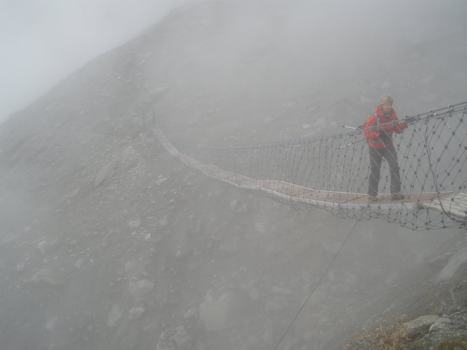
The guide book description does not suggest much altitude gain or loss, but there's definitely plenty of both throughout the day. Within the first 20 minutes we first had to descend and then head uphill to skirt round the bottom of a cliff and behind a waterfall. Shortly there after we came to an enormous rockfall area, obviously a very unstable area - previously the route went through a 100 metre tunnel but a rock slide had destroyed this (we saw cement fragments of this), so now hikers go over a very long (250 metre) suspension bridge............

But that was not the only challenge faced by those who built the path. The path also tunnels through cliffs and also tucks under an avalance prone area in this 3-sided tunnel.....

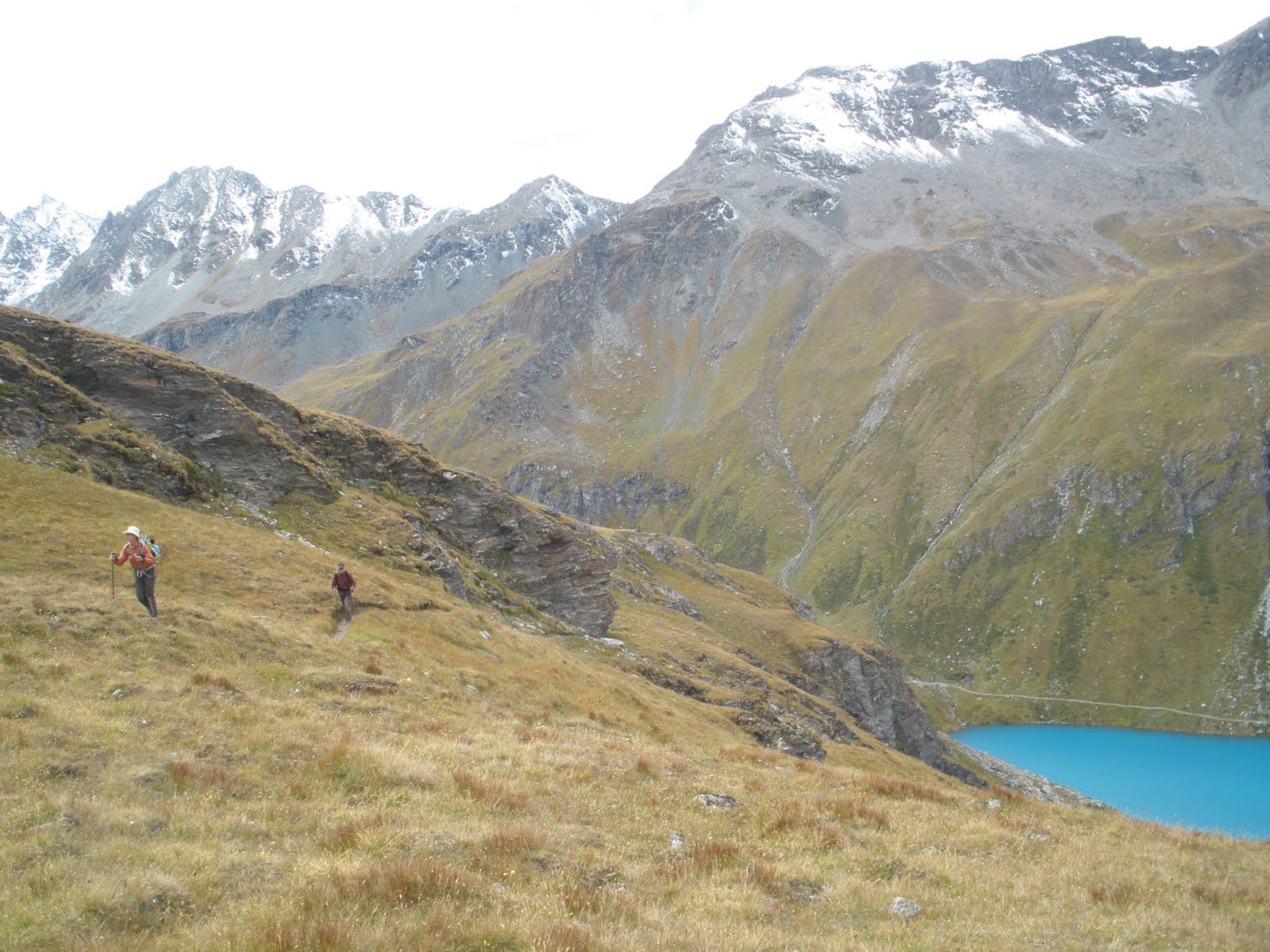
The weather had been playing peekaboo with us, the grey curtain of clouds would quickly pull aside to reveal tantalising glimpses of dazzling peaks, and then close again just as rapidly. But as if the weather god knew this would be our last afternoon of the hike, it decided to glow away all the clouds leaving us with an azure blue sky populated by a few fluffy white clouds. What a way to end our 10 day trip!

Europa Hut - 027 967 82 78 or 079 291 33 22

This is the only accomodation between Grachen/Gasenried and Täschalp/Ottavan and so is usually fully booked during the peak summer season. Even in September we were initially told that we'd have to sit on mattresses put out on the dining room floor! (luckily there were some cancellations so managed to get bunk beds).

The hut was built in double quick time by the Randa commune (which is almost directly below the hut in the Mattertal valley) about a decade ago. Despite its recent history it's quite cramped (nothing like the new Cabane de Moiry that i've raved about in a previous blog). It has 42 beds in 1 room with 4 beds, 3 rooms with 6 beds and a dormitory with 20 beds. This last one is definitely not to be recommended - the bunk beds are so tightly squeezed together they touch each other. This means chances of undisturbed sleep is pretty remote - there will always be snorers, or those who get to bed late or leave early in the morning.


These are the rates for the past season (2010)

Dormitoryin room
Accommodation without mealsSFr. 25 -SFr. 30th -
Bed and breakfastSFr. 35 -SFr. 40th -
Accommodation with half boardSFr. 55, -SFr. 60, -

More details about the Europa Way and Hut can be found at: http://www.europaweg.ch/

Friday 31 December 2010

Haute Route: Gasenried to Europa Hut

This is a cracker! A specially built high-level route that provides a fitting finale to the classic Haute Route. Unfortunately for the first part of this two stage ending the weather was not accomodating, though not as inclement as the previous day, but still following much the same pattern - grey and overcast with very short glimpses of sun and very short patches of rain (snow at higher altitudes) in equal measures.
From Gasenried the route follows a tarmac road that becomes a broad track, the path heads off from here and climbs through the pine forest. When we eventually get above the treeline we gain great views of the Bernese Oberland and the Great Aletsch glacier to the north, as well as fleeting glimpses of peaks closer by across and down the Mattertal. On a sunny day I'm sure it would have been a great place to linger....as it was today was not such a day.

No dawdling, no admiring the spectacular scenery, no relaxing on the penultimate day of our Haute Route adventure. Instead the track and the weather meant a day for careful, cautious walking, making sure that we did not slip, foot placement on loose rubble and scree, unstable or slippery rocks is a premium. The dangers are not only underfoot, but also overhead with black cliffs and steep slopes above which rocks are perched precariously, ready to roll down and crush us at any moment. As this is Switzerland, the danger spots have warning signs and in the more dangerous places, fixed chains are ready at hand.


For most of the day we felt like we were on another planet. From time to time the clouds enveloped us blanketing sound and sense of the Mattertal valley many metres below us, or the swirling clouds briefly parting to allow us furtive glimpses of jagged peaks or ominous forbidding cliffs, or a rock slide that we had to cross on a rather patch-work suspension bridge.

We were happy to reach the Europa Hut, it was one of the tougher sections of the Haute Route.

Click here for more comprehensive information about this section.


Wednesday 29 December 2010

Haute Route: Zinal to Gruben via Forcletta

A wonderful hike that takes in sylvan glades of pine, open moorlands and windswept barren ridges. Leaving the small pretty village of Zinal (there's a single pedestrian street with very old, but well maintained wooden cottages and mazots) we head up steeply on a wide track through a pine forest before reaching a small cottage - what a start - it definitely wakes up your heart, your lungs and legs! This is a good place to gather one's breath - using the excuse of looking at the wonderful scenery behind - - Pigne de la Lé, Grand Cornier and Dent Blanche. The path now traverses a more open hillside at an easier gradient.
As it nears the treeline the scenery is reminiscent of Scottish moorland.

Some 3 hours or so after leaving Zinal one begins the final climb up to the Forcletta pass, a barren saddle with stirring views of Bishorn and Weisshorn ahead and the jagged outlines of the Aiguilles Rouges.
The highlight of the descent down towards Gruben was a meeting with a local shepherd with 2 wiry, fun-loving Kelpies (Australian sheep dogs) and 2 very large (they were almost the size of a Shetland pony), shambling Central Asian Mastiffs. My hiking companion being from Australia immediately recognised the Kelpies, this is how we spent a great half hour talking dog. The Shepherd proudly demonstrated his whistle commands and how the dogs worked in tandem to make sure the sheep stayed together in a flock. What a wonderful way to break a long wearying descent.
A final note for this section of the Haute Route - we found route-finding a bit tricky first at Zinal itself, but later at Alpe Nava.


View Haute Route: Zinal - Gruben in a larger map

Haute Route: St. Niklaus to Gasenreid

The day we were meant to cross the Augustbord Pass turned out to be the worst day of the hike - heavy grey clouds, light rain, zero visibility - we didn't think the crossing would be much fun in such circumstances. As I've already crossed the pass a couple of times i was easy as the group consensus came round to skipping the pass and re-joining the route at St.Niklaus

Courtesy of the very efficient Swiss public transport system that involved one mini-van ride (down the Turtmann valley), a cable car ride (down to the main Rhone valley), a short hike and then a train ride to Visp followed by a connecting train to St.Niklaus, we were ready to start this part of the hike around lunch time. Most visitors only catch fleeting glimpses of this historic old village as they pass through on the train up to Zermatt, we fortunately had time on our hands for a leisurely wander-around - this took all of about 20 minutes!

There is not much to write about the hike - it takes about 2.5 hours and seems to be going straight up the hill!

When we set off from St. Niklaus there were rays of sunlight peaking through the clouds, but these soon disappeared and for the rest of the walk if it wasn't raining, it was drizzling or about to rain. The only others living things we saw on the uphill plod were these rather cute looking goats.

Sunday 26 December 2010

Cabane de Moiry - 027 475 45 34

The previous time we had been to the Cabane, my wife and I promised ourselves we'd never go back there. Next year we plan to go back - why this change of heart? It's very simple. I re-visited the hut as part of the Haute Route hike with some friends in September. What we found was a spanking brand new extension to the Cabane (officially inaugurated in early July). It had 8 well-thought out 4 bunk-bedded rooms, good hot showers (though on the expensive side - CHF5 for 3 minutes), clean toilets and wash facilities and the piece de resistance a dinning room with panoramic views of the Moiry Icefall. What a great reward for the 1.5 hour uphill slog from Glacier du Parking.

This cabane has definitely upped the game for mountain huts/cabanes in the Swiss Alps. Highly, highly recommended - at the height of the summer season you will need to book well ahead.

More information about the cabane can be found at their website:
Tel: 027 475 45 34

Cabane de Moiry to Zinal via Col de Sorebois

The amazing view looking back towards the Moiry Icefall. We had just descended from the Cabane de Moiry. The path continues down almost to the car park (parking du Glacier - buses as far as here from Zinal during the summer season) before beginning to contour round above the Lac de Moiry at about 2,500 metre contour line.

Contouring round the east side of the Val de Moiry is much easier than the long ascent or descent over Col de Tsaté of the previous day, but the morning did have a few short stretches of ups and downs before the final slog up to the Col de Sorebois. The talking point of this stretch was the stunning turquoise hue of the Lac de Moiry - what gives such amazing colours? Is it an algae? Is it the mineral deposits? Surely it isn't the Swiss Government emptying tons of colour dyes?!

By the time we reached the Col de Sorebois just before lunch the weather had lost its sunny demeanour. Grey clouds scudded across the sky and the wind had picked up. So, despite the impressive panorama of the mountains ahead of us contemplating their beauty at the pass was out of the question. We descended down a landscape that has been terribly scarred by the ski industry - wide, meandering ski pistes carved across the slopes, chair lift stations dotting the landscape, drag lifts running in various directions across the slopes. It may be look pretty and pristine under a coating of snow, but in the summer it looks just ghastly.

Fortunately, the slope is too steep and hazardous below the Sorebois cable car station (which brings up skiers/snow boarders from Zinal). This is what we took for the last leg into Zinal. This was one of the easier days of the Haute Route.


Sunday 10 October 2010

Hotel Banhof, Zermatt 027 967 2406

The stupendous sunrise view from our balcony.

This hotel next to the train station (as the name implies!) has just been refurbished very tastefully. We liked the wooden floor boards, solid wooden furniture and modern bathroom fittings. Our double bedroom with attached bathroom was good value for CHF130 (excluding breakfast). They also have dormitories and single rooms with attached and shared bathrooms. An added bonus in my view of this hotel is the well equipped kitchen that can be used by guests to prepare their own meals. This along with the cosy dining area makes this a good hotel for those planning to spend a few days enjoying the scenery, walks and climbs around Zermatt without spending a fortune on eating out every day.

You can check out the hotel website here.

Saturday 9 October 2010

Café - Restaurant L'écureuil, La Sage 079 651 0620

L'ecureuil was a lovely surprise. It is one of only 2 places where people can stay in the little village of La Sage. Last year we stayed in Hotel de la Sage so this year we decided to try this establishment. There are quite a few double rooms, as well as 3-, 4-, 6-bedded rooms, all with shared toilet and shower facilities. It seemed spacious - perhaps because it was only us (a group of three) and a father with 2 daughters staying the night - I can imagine it would be very crowded with a house full of hikers. Given that it was a short hike from Arolla to here, we had plenty of time to enjoy a cool beer on the terrace and take in the wonderful mountain scenery all round us - in the distance, Mt. Collon and Pigne d'Arolla, the Aiguilles Rouges. Booking in the summer season is strongly recommended - 027 283 2455 or 079 651 0620
Website (unfortunately only in French)

Tuesday 28 September 2010

Haute Route:La Sage to Cabane de Moiry

The route from La Sage begins a very short way down the road from the Cafe/Restaurant L'Ecureuil and gains height gradually on a gravel farm road that sweeps in long loops up a larch forest. The peaks - the Veisivis - dividing Ferpecle and Arolla valleys are the most prominent and further away those above Arolla, but the immense Dent Blanche is totally hidden from view.


The path steepens once the treeline is left behind, just before the small group of high-altitude cattle sheds at Le Tsaté and continue at a similar gradient upto and just beyond Remointse du Tsaté. An undulating gradient is soon followed by a steep last pitch up to the Col du Tsaté. The descent down the other side is of little note until one begins the final 400 metre climb up from the Parking du Glacier to the Cabane.


This final leg follows, for a short stretch, a narrow moraine ridge beside the Moiry Glacier before climbing up a steep rock band above which sits the Cabane - our day's destination.

Monday 27 September 2010

Haute Route: Arolla to La Sage

This was a short and easy day - a day to relax, let your limbs recover and prepare for the following days hike. The path went down the valley via Lac Bleu down to Les Haudères and then up to La Sage. The weather was grey with clouds with a chill in the area and drops of rain from time to time. The going was wet and slippery underfoot along the narrow forest path.


Initially the clouds hide the mountains, but gradually they dissipated to reveal jagged peaks. Soon after we reached Lac Bleu - which as the name implies - is really blue!

From here the path descends steeply to La Gouille - a small hamlet who's restaurant advertises its Flemish ownership by selling chips with mayonnaise, offering Belgium beer, flying the Belgium flag and displaying signboards in Flemish!

Les Haudères was reached around lunch time - but no restaurant seemed to be open. The summer season had passed and the winter season had yet to begin - many involved in the tourist trade had clearly decided to take their holidays. We quickly moved on up the hill to our destination for the day - La Sage.

Here a few hundred metres above the valley floor one gains a grand view of the mountains to the south.


View Haute Route: Arolla to La Sage in a larger map

Sunday 26 September 2010

Hotel du Glacier, Arolla - 027 283 1497

The intrepid gang about to set off....We had just spent a very relaxing night at the Hotel du Glacier after 2 hard days out of Verbier.

We had a double room and a single. The double with wash basin was a bit crammed with a double bunk bed and 2 singles squeezed in. The single with shower and balcony was a much better size. Toilet and bathroom were shared.

We paid CHF 77/person for the double and CHF 89/person for the single with demi-pension (half board). Well worth it given that we had a delicious 3 course dinner and good breakfast spread the following morning.

Decent room, reasonable price, good food and friendly staff - what more can you ask from a hotel?

For more details check out their website: www.hotelduglacier.ch

Haute Route: Cabane de Prafleuri to Arolla

After our previous days exertion we were slightly dreading today.....but the weather was just perfect and were soon enjoying the sun warming our faces and bodies. From the Cabane there is an initial half hour climb upto Col des Roux - where the morning sun greeted our arrival. From the Col it is a long, but easy descent towards Lac des Dix, along the way we saw some very healthy looking marmots, shapely snow capped peaks to the south and spindly rock spires to the east. This picture taken above the head of the lake shows the Col to the right and the path down and along the lake in the background.

As soon as we reached the track beside the lake we came upon a large number of other hikers - most seem to have come up from Le Chargeur for a day hike to Arolla. As the day was so balmy, the views so wonderful, we took our time and let all pass ahead as we dawdled along.

The going gets tough at the head of the lake as the path begins its long and unrelenting climb towards Col de Riedmatten. Kev Reynolds (of the ubiquitous guide book) says, in his understated, way; '....the last pull up to the Col de Riedmatten is a little demanding.' He must have meant the 30 metre zig zagging section of the path on loose gravel at 60 degree angle, then the rock field that the path weaves through followed by the final section just below the Col where boulder hopping intermixed with loose gravel sections.

For me the 'pièce de resistance' must be the ladders at the Pas de Chèvres just beyond the Col, which to my mind is much more preferable that going up the steep loose gravel path to the Col. This should definitely not be tried by anyone who suffers from vertigo. 3 vertical ladders bolted onto an almost vertical rockface - does get the adrenaline flowing.....


.....but once the ladders have been overcome we were rewarded with a stupendous views of giant peaks - Pigne d'Arolla, Mont Collon and even the Matterhorn in the very far distance.


View Haute Route: Cabane de Prafleuri to Arolla in a larger map

Cabane de Prafleuri - 027281 1780


The Cabane is privately owned and when we turned up were celebrating the 10th Anniversary of the new Cabane. On my previous visit i had stayed in the old building which had originally been built to house workers building the Grand Dixence dam (the long brown building to the right in the picture below).

We could hear the festive atmosphere as we descended down from the col (though it did sound like someone was trying to play the trumpet for the first time!). In the evening there was accordian, cello and dancing in the dinning hall - fortunately sound insulation was good ;-)

Dorms consisted of a number of 6 bedded-rooms, as well as larger rooms. A particular feature of the dorms were the height of the bunk beds - the one we slept in were a 3 level skyscrapers which were particularly difficult to get into and out off - unless you dropped out! Toilet facilities included 2 pay-showers (CHF 5 for 3 mins), 2 toilets and 4 wash basins.

Demi-pension (half board) was CHF 61.00

Saturday 25 September 2010

Haute Route: Cabane du Mont Fort to Cabane de Prafleuri

After an hour or so contour walking from the Les Ruinettes cable car station we took the Col de La Chaux track just below Cabane du Mont Fort - not because we chose it deliberately, but rather because we missed the signs towards Col Termin! The Kev Reynolds Guide book suggests this is the shorter route and more favourable in certain conditions - we are still trying to figure out what these could be! For on this perfect sun-kissed day, we found the route tiresome. Initially the path was a broad gravel track that swept up towards Mt. Fort where we were overtaken by mountain bikers pedalling slowly upwards. Once off this track, the going got rougher - loose gravel, unstable rock and then a small ice field.

Passing one of the small glacial ponds on the way to the Col.We soon reached the col to be rewarded by views of snow-capped La Pleureur, Grand Combin and Petit Combin. The descent on the other side was tricky - steep with loose gravel, and some boulder hopping - we weren't pleased to be doing this on our first day. Just above where this track joined that coming up from Lac Louvier we had a rest and feasted our eyes on the glacier sweeping down from Grand Combin. But soon we were slogging upwards again as we headed up the Col de Louvie. Here we were greeted by Buddhist prayer flags strung on a cairn.

The descent from this Col looked even steeper than the previous one! We had to cross the Grand Désert .......

.......before we could begin the ascent of the 3rd the final pass of the day - the Col de Prafleuri.

Definitely a hard first day to start the hike, but rewarding in terms of the views and the feeling of achievement at the end of the long day.

The guide book and the path sign boards suggest 5.5 hours. I estimate it took us 7.5 hours (including rest stops) to cover 10 kilometres with a height gain of 885 metres and loss of 740 metres.


Posted by Picasa


View Cabane du Mont Fort to Cabane de Prafleuri in a larger map

Haute Route: Verbier to Zermatt in 9 days


There are many, many personal blogs and sites about the 'Haute Route' (High Route) - the famous long distance walk linking up arguably the most famous mountain resort in the Alps - Chamonix andZermatt. There also seem to be an equally large number of different variations and ways of walking and skiing between the 2 resorts.

Some colleagues and I decided to do the Walkers' Haute Route this September. Due to time constraints (we only had 9 days) we decided to start of from Verbier, so missing out the following sections:
Chamonix - Argentière
Argentière-Trient / Col de la Forclaz
Trient / Col de la Forclaz-Champex-Lac
Champex-Lac-Le Chable
Le Chable - Cabane de Mont Fort

We rode up on first cable car from Le Chable up to Les Ruinettes and joined the trail from Cabane de Mont Fort on Saturday. In the following blogs I will describe the route, the hotels and cabanes where we stayed. But, of course, before we started the hike we spent a lot of time reading up on the route, deciding where to stay, booking the accommodation and checking the maps. Here are just a couple of the blogs that we found useful when planning this hike:

http://en.wikipedia.org/wiki/Haute_Route (i know this is not a blog ;-)
http://sites.google.com/site/stephabegg/home/tripreports/alps/walkershauteroute (complete with charts of altitude gains and losses and distance walked per day).

Worth its weight in gold proved to be the Kev Reynolds classic guide 'Chamonix-Zermatt, The Walker's Haute Route'. This is the bible of English speaking hikers. We used this for planning and throughout the hike.

Friday 10 September 2010

Mountain Hotel: Almagelleralp - 078 644 57 97

I haven't actually stayed here! But a friend has with his partner and boys for about 4 days. They loved it, finding the Anthamatten couple who run warm and friendly. The food is above standard fare with apricot tart which is made every day during the summer season, just delicious.

There was also enough walks for them to do - going to Saas Grund on the Alpenblumen Promenade or upto the Almageller hut above. It is in a great location not far from Saas Almagell.

There are doubles, family rooms and dormitories. For doubles it is CHF 70 per person for half board (demi-pension) with shared toilet facilities.

Contacts: jonasa@gmx.ch or phone 078 644 5797

Weekend hike: Zwischbergen Pass above Saas Almagell

A wonderful hike for the weekend. One starts up from the last village in the Saas valley, tiny Saas Almagell, who's most famous son is Pirmin Zurbriggen, multiple ski world champion. So in a country where skiing is almost a religion Pirmin is a demi-god!

The route starts from the big central space in front of the Tourist office heading east. It begins to head up almost straight away zig-zagging upwards through a pine forest. Various paths lead off in different directions, but signage is clear. After about one hour the trail levels out - you are at the mouth of the Almagellertal, after crossing the bridge you walk along a broad path to Almagelleralp. This mountain hotel celebrated its 100th anniversary this year.

The hotel is run by the friendly Anthamatten family with help of a number of equally friendly young ladies. It's a good place to stop for refreshments and take in the wonderful vista that is spread before you.

After the appropriate refreshments and joined by friends we wandered up the valley towards the Almageller Hut. The views of the Dri Horlini face in the afternoon light was indeed a sight to behold.

We spent the night at the Hut - the food was the usual Swiss Alpine Club fare - salad, pasta and for vegetarian tomato sauce with a hunk of cheese on the side, followed by mixed fruits from a tin - filling but not very appetising! All beds are in dormitories and cost CHF 39 per person, supper is CHF 25 and breakfast CHF 13.

Most people who stay at the hut are climbers fixated on conquering the Weissmes (4,017 m) or Portjengrat (3,653 m) and so set off before the crack of dawn. As we were only going one hour further up to the Zwischbergen pass (3,268 m) we set off at the leisurely time of 8 am. Just above the pass there are wonderful scrambling on the ridge leading to Weissmies.


View Saas Almagell - Almageller Hut in a larger map

Sunday 1 August 2010

Day hike: Nyon - St.Cergue

This day hike is part of the multi-day long distance Chemin des Crêtes du Jura path previously mentioned for the day hikes from Vallorbe - Le Pont and Col du Marchairuz - St. Cergue. The suggested route is the other way round to allow for less uphill. But as i live in Nyon and was starting off late I decided just to head straight up the hill - only if it was so easy.

The first section from Nyon to Abbaye de Bonmont is along tarmaced farm tracks and country lanes passing through the small farming villages of Arnex-sur-Nyon and Borex, both with long histories that are now submerged by a growth of standard new apartment blocks that is in the process of smothering the old village centres.Despite this growth, farmers still put up road-side stalls where they sell produce on-trust, such as this stall.....


With a blazing sun on my back and no views to speak off apart from the forested Jura range in front with the 'golf balls' of La Dôle marking the the high point of todays' walk).


From just below the Abbaye the path enters a cool mixed Oak forests. It is steep going from here along narrow paths. The route does from time to time make use of the tarmac road winding up the hill to La Barillette - here it is a relief to be walking on tarmac as the gradient is gentler.

La Bauloz was the first rest place as it had water, tables and benches. In the summer months the Chalet de la Dôle is also open for food and drinks. From there it is not far to the high point which on the day visited seemed to be full of people. The walk down from there to Nyon is relatively straight forward.

This is about 8.5 hour walk with rest breaks along the way. There are hourly trains from St.Cergue back down to Nyon from where one can catch main line trains to Geneva or eastwards via Lausanne.

If you want to do the walk starting from St. Cergue or get hold of a printable map visit this site.


View Chemin des Crêtes du Jura: Nyon - St.Cergue in a larger map


Sunday 25 July 2010

Day hike: Col du Marchairuz - Saint-Cergue

The Jura mountains straggle north-eastwards from close to Geneva and for large sections act as the border between Switzerland and France. The 'Chemins des Crêtes du Jura' runs along its spine from Dielsdorf to Nyon, a total of 310 kms divided into 15 stages, this day hike is one of these stages.

We took the morning bus from Nyon to the Col (it runs twice a day during the summer months - check the Swiss railways for timings) and after a leisurely coffee at the hotel set off along a dew covered forest track.

The Juras are an old limestonne mountain range which in this part is protected within Jura Natural Park. It is a living landscape used by villages on the lower slopes of the mountains using it as summer pastures for their cattle. Yes, we heard the cow bells clanking throughout our hike

Approaching the high point of the hike - Crête de la Neuve from which you can see Lac Leman (Lake Geneva), Geneva's Jet d'Eau, the Alps with Mont-Blanc massif right in front of you - unfortunately not today!


A characteristics of the Juras are the forests of coniferous trees, interspersed with herb-filled meadows, and low dry stone walls denoting ownership of the different pastures.


The hike takes about 4.5 hours, without any stops, but with so many places to dawdle and some great view points it would be silly to do it as a sprint. At the Saint-Cergue end there are hourly trains down to Nyon (you can find the timetable here).


Wednesday 26 May 2010

Day hike: Les Pléiades above Vevey, Canton Vaud.

My wife had wanted to see the famous fields of narcissi for, as she reminded me, over 8 years! Les Pléiades above Vevey was obviously the place to visit (given the small jam packed train) towards the end of May.

These are the hordes starting out from Les Pléiades.


Narcissi ahead.....

Jumping for joy, the wait is over!

The circuit doesn't take long - max a couple of hours. We wanted to make it a longer hike so actually carried on down to Blonay and by chance passed bigger fields of narcissi!

Map for this hike can be found at: http://www.narcisses.ch/narcisse_parcours_pleiades.php
with more info on other narcisses circuits at: http://www.narcisses.ch/ (all in French).